Dubai to create 3D map of infrastructure and service lines
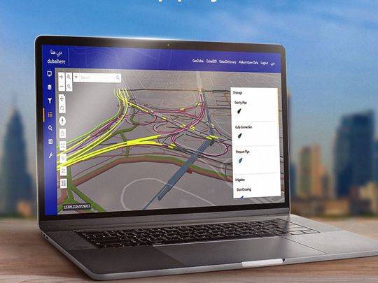
Image Credit: Twitter/@DMunicipality
Dubai: All infrastructure and service lines in Dubai, including those underground, will soon be available in 3D maps, thanks to Dubai Municipality’s 3D Infrastructure and Service Lines Map project. On Monday, the civic body announced that the project has been launched to position Dubai government as a fully smart model that provides best cutting-edge services in line with various international and innovative standards across all sectors.
Goals
Dawoud Al Hajri, director-general of Dubai Municipality, said: “The project will undertake a comprehensive study on choosing advanced technologies to build a 3D model and an inclusive map of geospatial data on infrastructure and service lines below the ground, integrating all the precise details within a single source of information. The study will further explore recent technological innovations in preparing underground infrastructure maps, including the Ground Penetrating Radar (GPR) technology, and choose the best to guarantee sustainable viability of data collection all over Dubai that keeps up with the latest information.”
Two phases
Mariam Al Muhairi, acting CEO of the Buildings Regulation and Permits Agency, said: “This project will be carried out in two phases, with the first phase involving analysis of available technology across the globe, assuring its quality, efficacy, and availability to provide it to the specialised team and training them on utilising it. On the other hand, the second phase involves examining all infrastructure service lines through the technology to update all the data.”
3D scanning
Several contemporary technologies will be used to provide a 3D scan of underground service lines, guaranteeing delivery of all relevant data and the accuracy of the geospatial database. The data includes details on all services, such as the irrigation, sewage, and rainwater lines maintained by Dubai Municipality, along with road lighting lines as well as power and water lines data, by the Roads and Transport Authority (RTA).
These underground service lines will be further scanned, processed, and delivered to the data-owning organisations to update them. These data are essential to achieving the Municipality’s goals of digital twinning, which include facilitating and speeding up operations that use 3D infrastructure data, including NOCs and infrastructure projects for relevant buildings.